From bees to trees: 3 student projects show that GIS is everywhere
Every day, there are fewer limits to what is possible with technology — and SAIT students are embracing the change. They’re experimenting with anti-gravity, helping companies find savings and learning about tech used everywhere from NASA’s Mars Rover to Alberta’s oilfields.
Now, Geomatics and GIS program students are presenting real-world solutions to scenarios presented by clients.
A geographic information system (GIS) is a computer system for capturing, storing and displaying data based on maps of the Earth. GIS is capable of providing information that is scalable to different models and scenarios, and it can enhance users’ decision making though:
- spatial analysis
- data integration
- precise environmental monitoring
- advanced visualization tools
- field data integration
Here are three incredible capstone projects completed by Bachelor of Applied Technology Geographic Information Systems students, showcasing just how broad GIS applications can be.
Generating buzz: Smart beehive placement model
Maps for bees? These tiny critters might be buzzing to go, but bumblebee populations are declining, and some species are categorized as endangered. Habitat is everything, and GIS can help narrow down options.
Working with Foundation of the Energy Collective (FEC), a charity that invests in research and sustainable living, students considered plausible locations for beehives.
The optimal location would allow colonies to stay healthy — not competing for food or interfering with human activity — while meeting local regulations (i.e., not building hives too close for comfort).
To find the perfect location, the students analyzed possible sites based on water and vegetation, powerlines, human activity and access. They combined GIS maps with in-person data and articles about habitat suitability, then developed custom map filters to create buffers that represented bylaw restrictions, keeping all hive placement within local regulations.
After eliminating “non-viable” zones for hives, the group determined that the ideal situation would be placing a group of hives — each with 5 metres of clearance around it for beekeeper access.
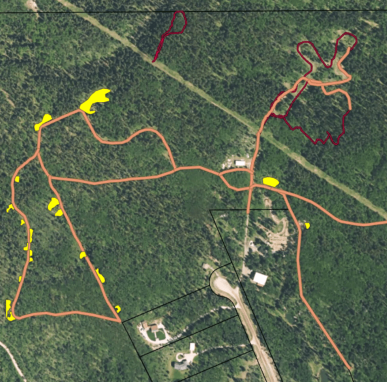
The students’ final GIS map, with all variables visible, including walking trails and non-viable zones. (Did you know SAIT has its very own beekeeping club? Follow them on Instagram, or, if you’re a current SAIT student, volunteer through Saitsa!)
Leveraging technology for social good: Urban planning
How do you build a city from scratch? From the ground up! When establishing new communities, understanding your environment is critical. Choosing a location depends on natural features and water source access.
With high-quality aerial images provided of Priddis Foothill County, students developed a sustainable community development dashboard. The dashboard offers an interactive overview of the project and to provides critical visualizations and real-time data to help monitor land use, infrastructure, and environmental impact. Blending agri-tech (technological advances in the agricultural sector) and scientific research, the group examined the region with a mind to develop a self-sustaining, economically viable community.
By looking at topographic maps, students identified ways to classify vegetation as “healthy” or “unhealthy,” then used remote sensing imagery to indicate this information on a map. They also identified water bodies (lakes, ponds, rivers and streams). They aggregated all this information — and more — into a dashboard.
The dashboard, intended for use in the project's initial and development stages, displays different land use zones (such as residential, commercial, agricultural, and ecological) and tracks the status of roads and ongoing infrastructure construction.
With the information compiled and the rules of land reclassification within Alberta consulted, the team determined the locations of communities, resources and an observation tower within Priddis Foothill County.
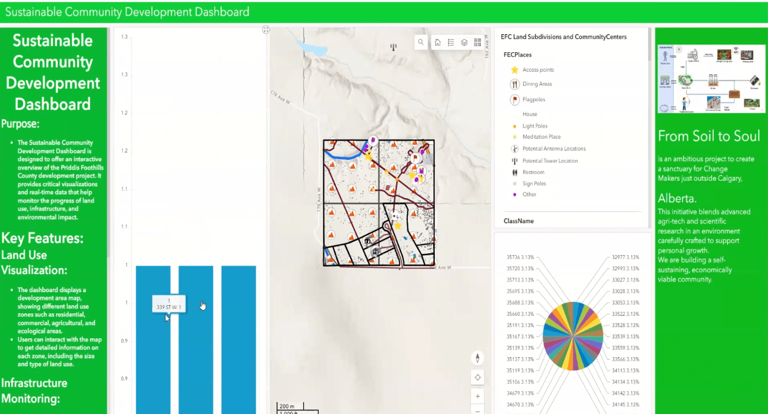
A snapshot of the students’ sustainable community development dashboard.
Saving Canadian forests and communities: Wildfire emergency response
As Canada’s wildfire season becomes longer and more intense, more communities and sites are at risk. To help comprehensively respond to this growing threat, students worked with our Centre for Innovation and Research in Unmanned Systems (CIRUS), part of SAIT's Applied Research and Innovation Services. They suggested using GIS capabilities to make real-time decisions, gain situational awareness and allocate resources.
To accomplish this, the students integrated geographic data into maps that could sync with a mobile application and a GIS-based emergency coordinator application.
The group focused on Frog Lake First Nation — a Cree community east of Edmonton chosen because of the disproportionate risk to First Nations during fire season — and assessed the area’s topographical features. The resulting maps showed the vegetation type, land cover and slope — all factors that affect wildfire spread.
Maps with these details would allow command centre and drone pilots to better predict the fire’s spread. The command centre could pair this with other information affecting spread, such as weather, to make decisions about air drops and water supply. Meanwhile, emergency responders on the ground could enter additional information into the students’ mobile application to further enrich the command centre’s knowledge and decision-making capacity.
Mindful of sites of cultural significance, the group also identified important areas to the community, so that resources could be best dedicated to protecting those locations.
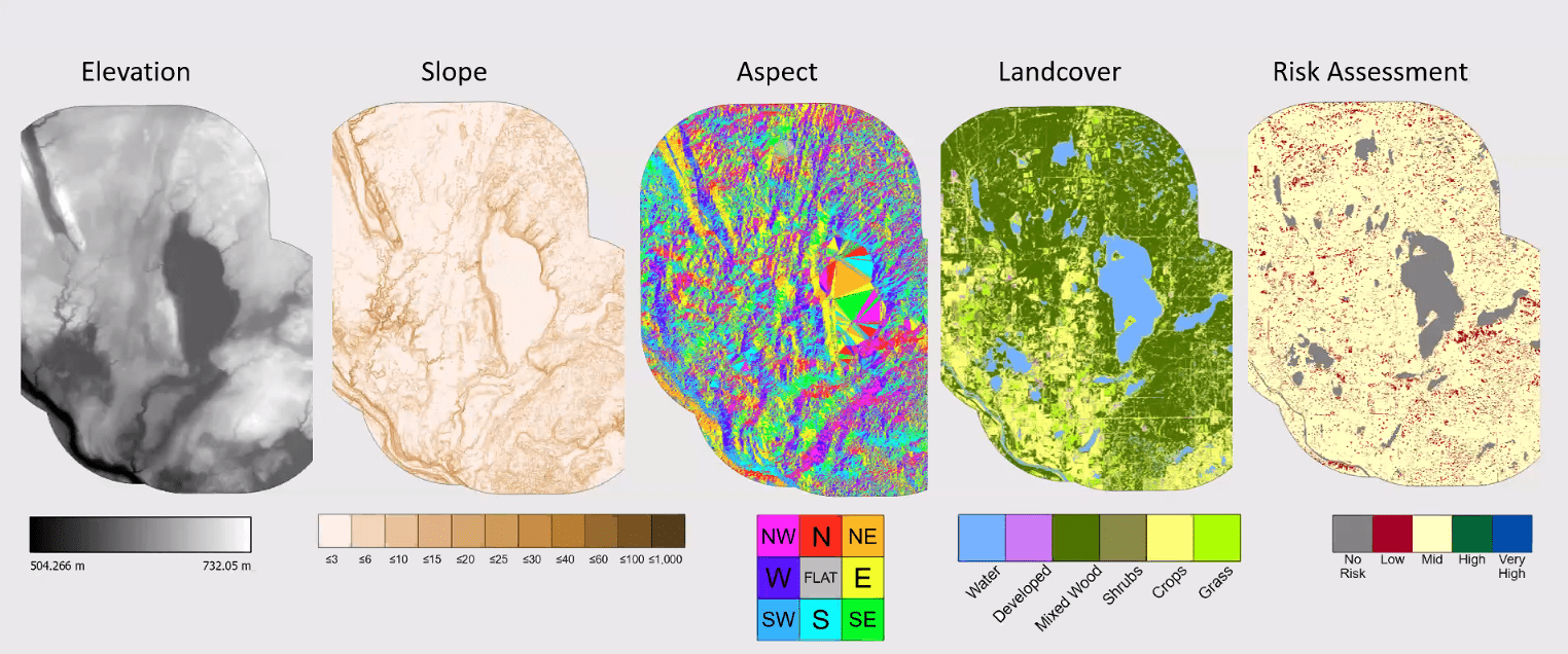
The students’ maps reflect the topographical attributes of Frog Lake First Nation.
Mapping your career path?
SAIT offers a Bachelor of Applied Technology in Geographic Information systems. This applied degree focuses on collecting, analyzing and interpreting data related to the Earth’s surface. Your classroom knowledge and work-integrated learning experience will prepare you for the real world, post-graduation.

Oki, Âba wathtech, Danit'ada, Tawnshi, Hello.
SAIT is located on the traditional territories of the Niitsitapi (Blackfoot) and the people of Treaty 7 which includes the Siksika, the Piikani, the Kainai, the Tsuut’ina and the Îyârhe Nakoda of Bearspaw, Chiniki and Goodstoney.
We are situated in an area the Blackfoot tribes traditionally called Moh’kinsstis, where the Bow River meets the Elbow River. We now call it the city of Calgary, which is also home to the Métis Nation of Alberta.