In March 2023, Dietra Raubach, Ian Palmer and James Wong — all Environmental Technology (EVT) students at the time — had the opportunity to practice flying drones inside the SAIT Connector, a flexible 6,000-square-foot learning space located in the Founding Builders Home Lab.
Developed by the School of Construction, the Connector is a unique drop-in space where students from any SAIT program can test out high-tech equipment like drones, virtual reality, high-grade sensors and thermal imaging cameras.
The experience gave Raubach, Palmer and Wong an idea for their upcoming capstone project: could they introduce drone technology into environmental assessments like mapping an old-growth forest?
Using multispectral drone imagery this way is a timely idea — one that SAIT EVT instructor and program specialist Colin Pattison is hoping to bring to his field school this fall.
“Traditional assessment methods — moving through the forest on foot to measure plant growth, health, biomass and species — are time consuming and labour intensive,” Pattison says. “But drones allow our students to gather multispectral data in minutes and interpret it in a few hours.”
For their final project, called Bringing Drones into the EVT Program: A Pilot Project, Raubach and her team proposed using SAIT’s DJI Matrice 300 RTK — an industrial-grade mapping inspection drone — and a LiDAR sensor borrowed from Canadian commercial drone supplier Measur. Their goal was to compare calculating forest density from above with traditional surveying methods on the ground.
Soon another student frequenting the SAIT Connector, Joy Dutta, was invited to get involved in the capstone — even though he was in the Geomatics Engineering Technology program. What he brought to the project were practical skills including land surveying, remote sensing and digital mapping — plus the new advanced drone pilot licence he had earned through the Connector.
“I work a desk job, but geomatics is usually field work,” Dutta says. “I was really interested in the project because of the opportunity for outdoor research. The SAIT Connector shows how the same sets of information can be used by different fields.”
Next, Architectural Technologies student Erick Alvarado was recruited to help the team capture imaging and video while conducting their forest surveys in Kananaskis Country. A Colombia native, Alvarado was excited not only by experiencing his first snowfall during filming, but also by the diverse collaboration with fellow students.
“Each of us has different skills, but the empathy we have makes things work,” Alvarado says. “We were from various programs seeking different research, but we were helping each other.”
After using the drones to collect data, the students used computers to process the information and compare it to their terrestrial data.
In fact, the team gathered so much data that they were unable to analyze everything before the semester’s end. Their findings have been shared with their instructors in hopes that future students can continue the project.
Drones and data
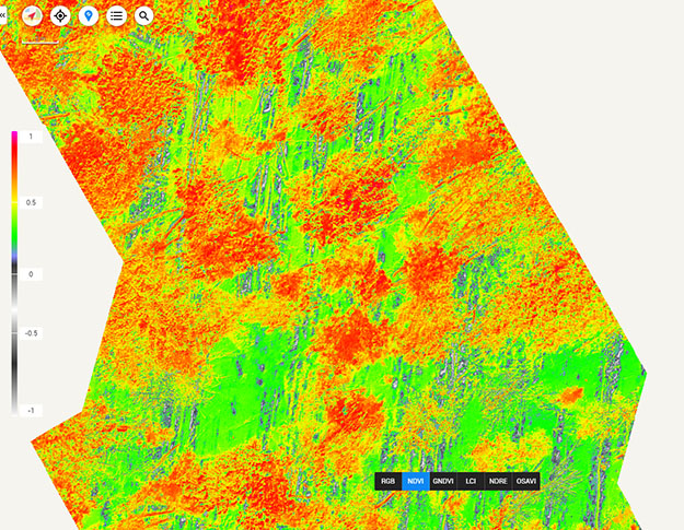
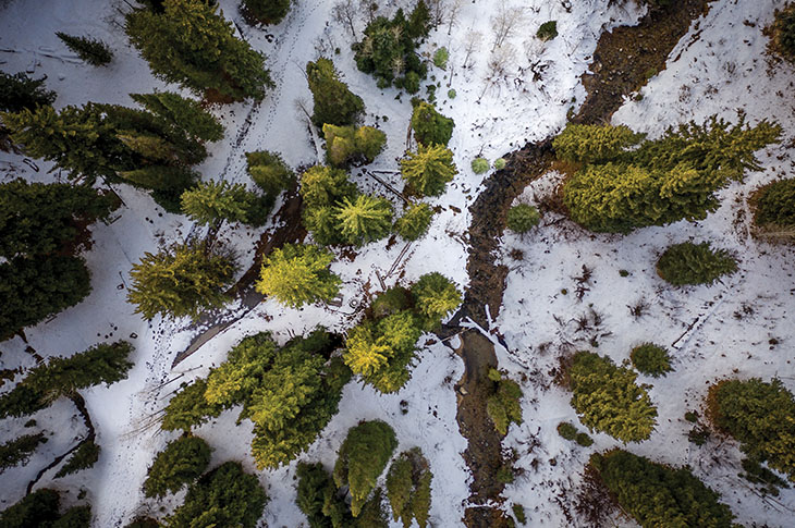
Students attached sensors to drones for mapping old-growth forest near Bragg Creek, then used the Normalized Difference Vegetation Index (NDVI) to analyze the data gathered.
- BLUE and GREEN areas represent bare ground or snow
- YELLOW shows sparse ground cover
- RED represents dense, green vegetation
- BRIGHTER COLOURS indicate healthy vegetation
- RGB refers to the red, green and blue model used in GIS mapping

The same data was also analyzed using four additional indices:
- GNDVI Green Normalized Difference Vegetation Index: Measures photosynthesis rates and plant stress
- LCI Leaf Chlorophyll Index: Assesses chlorophyll content in dense areas
- NDRE Normalized Difference Red Edge: Another index for analyzing chlorophyll content
- OSAVI Optimized Soil Adjusted Vegetation Index: Maps density of tree canopies and other growth

Oki, Âba wathtech, Danit'ada, Tawnshi, Hello.
SAIT is located on the traditional territories of the Niitsitapi (Blackfoot) and the people of Treaty 7 which includes the Siksika, the Piikani, the Kainai, the Tsuut’ina and the Îyârhe Nakoda of Bearspaw, Chiniki and Goodstoney.
We are situated in an area the Blackfoot tribes traditionally called Moh’kinsstis, where the Bow River meets the Elbow River. We now call it the city of Calgary, which is also home to the Métis Nation of Alberta.
